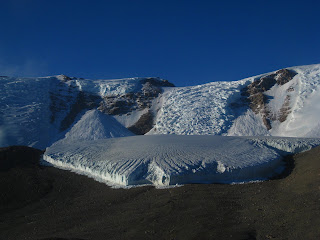
This is a more recent adventure I got to partake in which very few people down here have the ability to do. Because I am on the Search and Rescue team I was able to fly out to some remote field camps on a reconnaissance trip to have some terrain familiarity and also know where the resources are located if we ever need to actually do a rescue. I was fortunate to head to the Dry Valleys which are across
McMurdo Sound on Antarctica. I can now say I have been to Antarctica and not just to a big island that is really far south. There is a fair amount of science that happens in the Valleys but I don't know what it is right now because none of those scientists have arrived yet. Right now it is just seal and penguin researchers and then folks studying the atmosphere. When I find out what happens in the dry valleys I will let everyone know. In the meantime I will just have to talk about how awesome my flight was. We were in the air for about 3 hours total and got to fly over the sea ice edge and see open water and then fly around in these enormous valleys that have a bunch of exposed rock, kind of unusual down here as most things are covered in ice, and then see the gigantic ice sheets that surround them. This place is beautiful when you get away from McMurdo, even on short walks or trips in a vehicle out on the sea ice, but especially really far away in a helicopter. It was another mind blowing experience and a place that I would hope to get out and actually walk around some day. The top left photo is of the Goldman Glacier that lives above Lake Hoare, in the Taylor Valley. It is probably a couple miles wide and like most glaciers down here is still advancing.
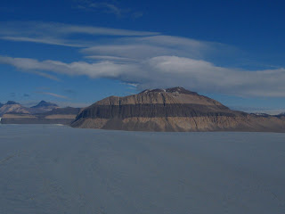
The middle photo is of a random mountain, that I don't know the name of, that sticks up in the middle of the of the Taylor Glacier. The Taylor Glacier is huge, bigger than anything I have been on in Alaska at least where this photo is taken, probably about 15 miles across. I just really liked band of rock that ran through the middle of the mountain which exists in the final photo as well but is just hidden under the ice.
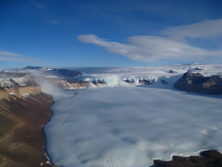
The last photo is of an icefall, which I don't have the name of, where ice from the the eastern continental ice shelf is funneled into and then pushed over that cliff into the Upper Wright Glacier. It is probably about 5 miles across at the bottom edge of the photo. In the left hand corner of this photo you can see a white could coming down off the upper glacier. The winds were very strong over there and this is a giant cloud of blowing snow. This whole area is a giant specially managed area that is off limits to almost everyone. When you go in there you have to carry out all your waste including pee and poop so as to not leave a trace. This is somewhat of a surprise since McMurdo is one giant trace from both the military days and even now during the National Science Foundation rein, although things are getting better from what I hear.
 This is a more recent adventure I got to partake in which very few people down here have the ability to do. Because I am on the Search and Rescue team I was able to fly out to some remote field camps on a reconnaissance trip to have some terrain familiarity and also know where the resources are located if we ever need to actually do a rescue. I was fortunate to head to the Dry Valleys which are across McMurdo Sound on Antarctica. I can now say I have been to Antarctica and not just to a big island that is really far south. There is a fair amount of science that happens in the Valleys but I don't know what it is right now because none of those scientists have arrived yet. Right now it is just seal and penguin researchers and then folks studying the atmosphere. When I find out what happens in the dry valleys I will let everyone know. In the meantime I will just have to talk about how awesome my flight was. We were in the air for about 3 hours total and got to fly over the sea ice edge and see open water and then fly around in these enormous valleys that have a bunch of exposed rock, kind of unusual down here as most things are covered in ice, and then see the gigantic ice sheets that surround them. This place is beautiful when you get away from McMurdo, even on short walks or trips in a vehicle out on the sea ice, but especially really far away in a helicopter. It was another mind blowing experience and a place that I would hope to get out and actually walk around some day. The top left photo is of the Goldman Glacier that lives above Lake Hoare, in the Taylor Valley. It is probably a couple miles wide and like most glaciers down here is still advancing.
 The middle photo is of a random mountain, that I don't know the name of, that sticks up in the middle of the of the Taylor Glacier. The Taylor Glacier is huge, bigger than anything I have been on in Alaska at least where this photo is taken, probably about 15 miles across. I just really liked band of rock that ran through the middle of the mountain which exists in the final photo as well but is just hidden under the ice.
  The last photo is of an icefall, which I don't have the name of, where ice from the the eastern continental ice shelf is funneled into and then pushed over that cliff into the Upper Wright Glacier. It is probably about 5 miles across at the bottom edge of the photo. In the left hand corner of this photo you can see a white could coming down off the upper glacier. The winds were very strong over there and this is a giant cloud of blowing snow. This whole area is a giant specially managed area that is off limits to almost everyone. When you go in there you have to carry out all your waste including pee and poop so as to not leave a trace. This is somewhat of a surprise since McMurdo is one giant trace from both the military days and even now during the National Science Foundation rein, although things are getting better from what I hear.
1 comment:
Hey Galen,
How is my favorite nephew (don't tell Jeff. You know he'll whine and be soooo jealous :) ) Your mom just gave me your blog and yikes! Plz tell me you are keeping a journal as well cuz seriously, you are as close to 'adventure' as I'll ever get. Be well dear and be safe. Hugs, Aunt Kathy
Post a Comment